The Lost Highway
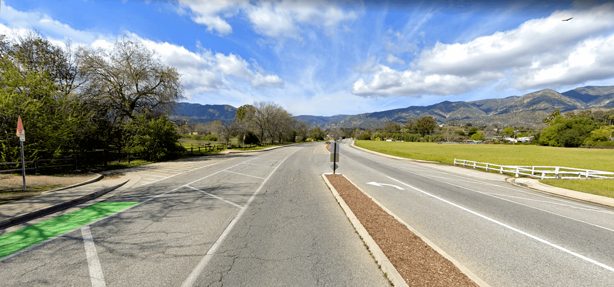
Written by Andy CarlsonIn the whole Ojai Valley, there is only one double-lane, divided highway: the segment extending from the “Y” intersection at the Vons shopping center, out a little over a half mile to the five-point intersection of El Roblar Drive, close to the Saint Thomas Aquinas Catholic church. Hundreds of motorists use this stretch of the 33 (Maricopa Highway) daily, and a few probably wonder about the significance of this short multi-lane stretch.
GOOGLE STREET VIEW
Heading north toward Ojala, just after Nordhoff High School, there lies an intersection to nowhere; left-turn lanes going into roadless fields. What was the reason for making such an intersection?
To understand this highway relic, we must go back to the end of the First World War. Ojai had a much smaller population, around 2000 or fewer souls in the whole Valley. The railroad from Ventura to Ojai had a building-free stop at the current site of Rotary Park. It was named Grant Station, where travelers met with stage coaches and motor cars going on to Wheeler Hot Springs and the Matilija Canyon.
Back then, there was no “Y” intersection, as the road that veers left to form the “Y” had yet to be built. Getting to Wheeler’s resort or Meiners Oaks required utilizing Del Norte Road, then turning left at the Ojai Cemetery onto Cuyama Road. At the bottom of the westbound grade, one could turn right for Wheeler Hot Springs or continue straight to Meiners Oaks. The reason for this seemingly unnecessary detour was to avoid the wetlands between what is now Nordhoff High and the Catholic Church.
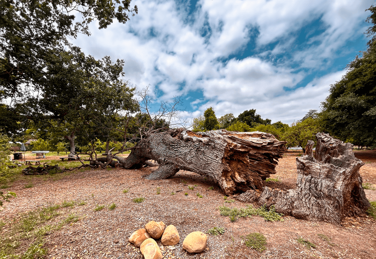
A fifth-grade teacher, Robert Smith, told those of us at Meiners Oaks Elementary School who would listen that our school’s site, extending out towards the Nordhoff school area, had, until relatively recently, been wetlands with a shallow lake. He said the large, heritage Valley Oak trees which remained at the time were remnants of those wetlands; they were the oaks surrounding that lake. He mentioned that the Chumash came for the acorns when the acorn season supplied lots of food for these indigenous peoples. I remember about a dozen large, old Valley Oaks from the late 1950s and early 1960s, where I often played in the pastures and orange groves. Slowly, the oaks succumbed, one by one, until around 1991; three remained behind the Nordhoff football stadium and one by what is now Poco Farm. Now there are none. I now know that the dearth of young Valley Oak replacements was due to the land lacking the soil moisture necessary for that species to thrive.
There exist aerial photos of this area taken in 1928, which I first saw on an information post in the Ojai Meadow Preserve. This predates the draining of the area’s wetlands and the construction of the Maricopa Highway route. What happened to those wetlands?
The loss of the wetlands is due to a late-1920s decision the State of California and the Feds made in “land reclamation,” a poorly named activity that called for creating a network of drainage ditch canals designed to allow the still water to migrate off-site towards the Ventura River. The Lomita Storm Drain then directed the collected stormwater into the creek that veers south by the Tico Road/Lomita Avenue junction, eventually flowing into the Ventura River. This draining activity and road-building was done in the late 1920s and early 1930s as part of the Maricopa Highway project and made a more direct road route possible.
However, these drainage canals’ efficiencies were limited due to insufficient elevation drops, meaning water left the area slowly, making for standing water ponds during high rainfall events. Because of this, CalTrans had the excuse to spend money on further channelizing the Lomita Drain, extending it to the Ventura River directly west. The storm drain was lowered to allow it to diverge from the Tico Road creek to go past the fire station on a more direct route to the Ventura River.
Despite the efforts of CalTrans engineers, the intersection of Cuyama Road and Highway 399 (the name of Highway 33 at that time) continued to be a nuisance in stormy times. The elevation drops still caused ponding of slowly draining water during rain events, such as the flooding of January 1969. With California State dollars awaiting grants for park and environmental projects, the Ojai Land Conservancy leveraged those funds to solve the flooding problem. With community support, they restored much of the lost wetlands, engineering it to avoid the need to move water off-site to the Ventura River by simply allowing it to percolate back into the groundwater. The results work beautifully to plan and are a great example of how properly spent money can have significant positive effects. I don’t think standing waters have blocked this intersection since the Land Conservancy’s restorations started in the early 2000s.
The Ojai Valley Land Conservancy’s Meadow Preserve
All this additional drainage work was done in concert with the 1950s/1960s planned extension of the Ojai Freeway up to Rice Road in Meiners Oaks, utilizing Lomita Road. Lomita, however, stopped short of Rice at Luna Drive, near the Meiners Oaks Fire Station. CalTrans solved this problem by purchasing the residential house of the James Hall Family, and after that obstacle was removed, Lomita Road was extended down to Rice Road. Knowing its intended purpose, travelers now may understand why that road is so broad.
THE OJAI FREEWAY THAT NEVER WAS
CalTrans wasn’t finished, as the proposed freeway traffic would be hampered by making the hard ninety-degree north turn of Lomita Avenue, going past the elementary school and up three blocks to El Roblar. The plans called for extending Lomita out directly to the Maricopa Highway. This is why the Maricopa Highway was remade into a divided four-lane highway, complete with the aforementioned intersection to nowhere, the preliminary infrastructure for what was to be the last Ojai Freeway off-ramp, exiting to Lomita Road. But the freeway extension was never built.
So, now you know the story of Ojai’s vestigial highway and off-ramps. The City of Ojai, in conjunction with CalTrans, has been planning on making this stretch of road more bicycle-safe by reducing the route back to single lanes, divided for safety. After more than two years, this Active Transportation Project is still expected to be done.
Thank you to Nathan Wickstrum from OVLC for sharing his source for aerial photography of the Valley.


